


Use the
Planning a Trip to Japan?
Share your travel photos with us by hashtagging your images with #visitjapanjp
HOME > Japan’s Local Treasures > Nikko's Iroha Slope Sightseeing Road
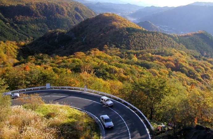
Enjoy amazing views along this route connecting Nikko with Lake Chuzenji
Nikko City, Tochigi Prefecture

The Iroha Slope is a pair of spectacular sightseeing roads connecting the World Heritage-listed town of Nikko, around 150km north of Tokyo, with serene Lake Chuzenji in the mountainous Oku-Nikko region. Centuries ago, mountain ascetics would walk this winding route to reach sacred Mt. Nantai or Chuzenji temple from Nikko.
The modern road is made up of two one-way routes: the first Iroha Slope road (built in 1954) runs downhill from Lake Chuzenji to Nikko, while the second Iroha Slope road (built in 1965) climbs uphill. Together, these two roads twist around 48 sharp curves. In Japanese, zaka is a slope, and Iroha refers to a famous Heian-period (794–1179) poem which in its composition uses the 48 hiragana characters of the old Japanese alphabet only once each. Each of the Iroha Slope’s bends is marked by a sign displaying one of these hiragana characters.
On the drive up, it's possible to pause at the Akechidaira Observatory to fully admire the panoramic views of the Nikko National Park. The Iroha Slope is also famous for being one of Japan's best locations for viewing autumn foliage every October and early November. During this season, the 16km road can become very congested.
How to get there
From Tokyo Station, take the Tohoku Shinkansen to Utsunomiya Station (48 minutes), then take the JR Nikko Line to Nikko Station (42 minutes). Next, take a bus from JR Nikko Station to Akechidaira (35 minutes).
Chugushi, Nikko-shi, Tochigi-ken
Links
More Information
Kanto Region | JNTO Official Website
Tochigi Prefecture | JNTO Official Website