


Travel Logs Mt. Ishizuchi

Mt. Ishizuchi is located in Ehime Prefecture on the island of Shikoku. Sitting at an altitude of 1,982 meters, it’s the tallest peak in western Japan. To be more precise, Mt. Ishizuchi refers to a mountain range made up of multiple peaks which includes Mt. Tengu, the highest peak out of this group, Mt. Misen, which comes to a close second, Mt. Nansenbo and more.
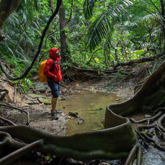
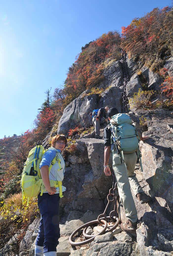
Mt. Ishizuchi is considered to be a sacred mountain with deep roots in Japan's native mountain-worshiping religions, and its importance has landed it on the list of Japan's seven sacred peaks. Ishizuchi Shrine has been around since ancient times, and there is a route up the mountain with iron chains along the way, especially in steep sections, which are used in religious mountain training practices. The mountain climbing and hiking experiences offered here have a deep sense of tradition, and it's sure to be a memorable hike that's unlike anything else.
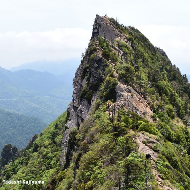
When it comes to the most well-known mountain hiking routes for Mt. Ishizuchi, there are a couple of different approaches. The first is the Omote Sando route, where you take the Ishizuchi Tozan Ropeway and start your mountain hike from Ishizuchi Shrine Jojusha. The second approach is the Tsuchigoya route, which is when you take the Ishizuchi Skyline or car up to enter the mountain area via Tsuchigoya Yohaiden. For this article we're going to focus on the Omote Sando route, which gives a full tour of the beauty and history that's on offer at Mt. Ishizuchi. This article also features some gorgeous photos provided by the mountain photographer Tadashi Kajiyama.

Tadashi Kajiyama
Tadashi Kajiyama is a photographer born in Nagasaki Prefecture. He successfully climbed the Himalayas at the age of 24. His focus is on mountain photography, and his photos have been featured in Yama to Keikoku, and other mountain-related periodicals. His work also appears in numerous articles and a large number of guidebooks about mountain climbing.

If you are traveling to Mt. Ishizuchi using public transportation, start at Iyosaijo Station, which serves the JR Yosan Line, and find the Setouchi Bus that departs from there. Take the bus bound for Nishinokawa, and then get off at the "Ishizuchi Tozan Ropeway-mae" stop. The bus makes four round trips each day, and the ride is about one hour in total.

The Ishizuchi Tozan Ropeway connects Sanroku-Shimodani Station (455 meters elevation), with Sancho-Joju Station (1,300 meters elevation). This is where visitors can enjoy an 8-minute stroll out in the fresh air. If you take a look out the window during the ropeway ride as it ascends the steep face of the mountain, you'll be greeted with a stunning scenic view of the mountains.

Once you get off at Sancho-Joju Station, you will find the trailhead and can start hiking up the mountain. There is a well-maintained mountain hiking path here to walk along, which will take you through Okumaegami-ji Temple as you head toward Ishizuchi Shrine Jojusha. Along the way you'll find signboards that mark the direction you need to take, so make sure to keep your eye on those to stay on the right track.

The walk to Ishizuchi Shrine Jojusha from Sancho-Joju Station will take about 25 minutes after you head out from Sancho-Joju Station. The shrine is located at the 7th hiking station for Mt. Ishizuchi, and serves as one of the main bases for mountaineering in this area. There is an exceptionally scenic view of Mt. Ishizuchi from inside the Yohaiden Hall of the shrine.

Ishizuchi Shrine was first built around 1,330 years ago as a religious site dedicated to Mt. Ishizuchi. The shrine itself is made up of four distinct shrine sites: Chugu Jojusha, Kuchinomiya Honsha, Okunomiya Chojosha, and Tsuchigoya Yohaiden. There is also a cafeteria and shop at Jojuya Shiraishi Ryokan which is located on the shrine’s grounds.

From Jojusha Shrine, begin making your way down Hatchozaka, a 1.2-kilometer downhill slope with an elevation difference of about 130 meters which leads to the Hatcho-bunki junction point. As you go down the slope, you'll encounter an overgrowth of a broad range of various plants. After you pass through the torii gate, there is a bench where you can see a sweeping view of the summit.

Make your way through Hatchozaka and then proceed around the trial chains. These are to test yourself before you reach the other climbing chains that are further along. Following that, you'll come up on a forest area called Zenshagamori. There is an amazing panoramic view of Mt. Kamegamori and a tiny mountain hut here, so feel free to slip in a little break here before you continue hiking.

The Yoakashi-toge mountain pass is situated about halfway between the start of the mountain trail and the summit, and it's one of the most scenic destinations on the route. As you make your way up the pass, you'll see the view open up more and more until the entirety of Mt. Ishizuchi is on display.

If you are enjoying your hike up Mt. Ishizuchi, be sure to keep your eye on the vegetation and the way it radically varies at different elevations. You'll notice the Erman's birch trees, which are a lot like Japanese white birch, as well as fields of bamboo grass that completely cover the ground with verdant greenery, all of which become even richer in color as you get closer to the summit.

After you make your way up the stairs, you will see three different chains. These climbing chains are used as part of a training process involving religious practices centered around the mountain. There is an alternative path here, so you don't have to climb using these chains if you're not confident in your abilities. The first of these chains is shorter than the others that follow it, with a length of about 33 meters.

When there is about 600 meters left before reaching the summit, there is a point where the route with the second and third chains meets up with the detour route. From the area around the torii gate in front of the second chain, you can catch a view of the steep chain climb that leads up to the summit.

The second chain is 65 meters long. Even if you climb up using the second chain, you still have the option to switch over to the detour route after this section. This gives you a chance to consider your physical abilities and other factors before deciding if you want to continue on and challenge yourself with the third chain.

The public restrooms available here are the only ones that you will find on the Omote Sando route. The only other bathrooms are at Jojusha Shrine and the summit of Mt. Misen. Be sure to pay attention to the rules here as well, which include paying the designated tip and disposing of your toilet paper separately.
The third chain is 68 meters long. The slope here is practically a vertical climb, and it’s much more difficult and dangerous than the second chain before it. If you have even the slightest hesitation or doubt in your abilities, it’s recommended that you take the detour route.

You’ll come to reach Mt. Misen (1,974 meters), one of the summits of Mt. Ishizuchi, after you ascend the stairs located near the third chain. This area is a shrine site that houses Okunomiya Chojosha, which is a part of Ishizuchi Shrine. Once you reach the end of the mountain ridge, you'll be greeted with a view of Mt. Tengu towering right up into the sky.

Okunomiya Chojosha has a mountain lodge attached to it called "Chojo Sanso" where both mountain ascetics and regular hikers can stay. The lodge is open to guests from early May to early November, and it can accommodate about 50 guests in total, which means that reservations are required to stay here. In addition to that, they have a shop on the 1st floor, a rest area, and an eatery that are all open to everyone.

Continuing on from the summit of Mt. Misen, make your way towards Mt. Tengu's summit, which is well-known for its distinct pyramid-like shape. This section involves steep inclines and there are sections where it can be difficult to maintain your footing, so if you have any doubts about your hiking equipment or fitness levels we recommend that you turn back at Mt. Misen.

That finally brings us to Mt. Tengu (1,982 meters), the highest of all the peaks at Mt. Ishizuchi. At the summit here you can enjoy a 360-degree panorama of the surrounding mountainous landscape and foothills. You can also take in views of the Seto Inland Sea and the Pacific Ocean, as well as Mt. Aso in Kyushu, and Mt. Daisen in the Chugoku Mountains.

Once you've had your fill of the fantastic view at the top of Mt. Tengu, take care as you start your hike back down the mountain. If you're looking for a place to rest your weary body, there is a hot spring that accommodates day-trip guests, a hot spring ryokan inn, and other options right next to the ropeway at Sanroku-Shimodani Station.

Other activities to enjoy
Mt. Ishizuchi is brimming with lush nature and picturesque scenery, and there are plenty of other activities to enjoy besides hiking the mountain. There's the UFO Line, a driving route that carves around the ridges of Ishizuchi's mountain range with altitudes that vary from 1,300 meters to 1,700 meters, which has earned it the name, "Road in the Sky." This driving route is an amazing way to experience the mountainous terrain here.

Once the winter season rolls in, the Mt. Ishizuchi area turns into a popular hub for snow sports. Ishizuchi Joju ski grounds are a go-to destination that offers a wealth of fun activities to enjoy in the snow. The location is 1,400 meters high, making it a great place to see panoramic views of the Seto Inland Sea and surrounding mountains.
When you think about the history of mountain-based religious practices here while overcoming the rugged mountain trails and climbing chains that countless mountaineers and ascetics have tested themselves with before you, and then finally reach the summit to find a stunning scenic view, it gives you a real sense of spiritual and physical accomplishment.
If you're looking for even deeper knowledge about the cultural aspects around Mt. Ishizuchi's mountain-worshiping practices, then we recommend a Shugendo mountain asceticism experience where you hike up the mountain with Shinto priests and Shugendo practitioners from Ishizuchi Shrine in accordance with a set of customary practices. There are also options for advanced climbers looking for an added level of difficulty in their hiking adventures. These include starting your hike from the foot of the mountain without the use of the ropeway or car, as well as traversing across Ishizuchi's varied mountain range.
Mt. Ishizuchi is famous for being one of Japan's most sacred sites for mountain-worshiping practices, as well as boasting the highest peak in western Japan. The hike up this mountain is an extraordinary way to experience history and tradition along with unspoiled nature.
Links