


Travel Logs Mt. Asahi

Mt. Asahidake is the highest peak of the Daisetsuzan Mountain Range, a series of mountains in central Hokkaido that are over 2,000 meters tall. Boasting the highest peak in Hokkaido at 2,291 meters, there are hiking routes that start from the top of Asahidake Ropeway, which connects Sanroku Base Station (1,100 meters above sea level) to Sugatami Summit Station (1,600 meters above sea level). These hiking routes have varying levels of difficulty and terrain that allow visitors to enjoy the grand nature on offer to the fullest.
The best season for hiking and sightseeing ranges from mid-June, when the mountain trails open, to late September, when you can enjoy vibrant fall colors (the earliest in Japan). Snowfall begins in early October, transforming the mountain into a stage for a variety of snow-related activities.
This article will feature photos from a mountain photographer who has been active in the area for many years, capturing the charms of Mt. Asahidake from the workings of nature to the rare ecosystem unique to Hokkaido, making you feel like you're there, too. An extensive hiking adventure is just about to get started.

Yukinori Otsuka
Yukinori Otsuka lives in Higashikawa Town, Hokkaido, and works as a mountain photographer and guide centered around the Daisetsuzan area. Otsuka is fluent in English and has plenty of experience as a guide for guests from Asia, Europe, and North America. He has made many contributions to the mountain-related magazines "Yama to Keikoku" and "Gakujin."

If using public transport to access Mt. Asahidake, the most common option is to take the 90-minute shuttle bus (Ideyu-go) from Asahikawa Station via Asahikawa Airport.
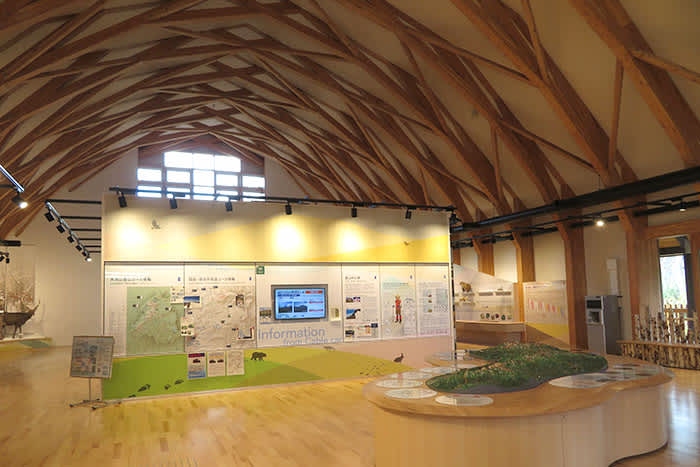
Get off at the final stop and head for the Asahidake Visitor Center. Here you will find information on the ropeway operating conditions for the day, pamphlets in multiple languages, and useful information for hikers.

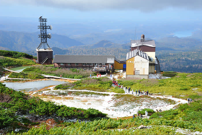
From Sanroku Station on the Asahidake Ropeway located near the Visitor Center, you can enjoy a 10-minute journey in the sky as you head towards Sugatami Station, located 1,600 meters above sea level. The view from the only ropeway in Japan that reaches above the forest line limit is truly spectacular, especially when the leaves change color in autumn!

Round Trip to the Summit Course: Sugatami Station - Sugatami Pond - Mt. Asahidake Summit
Once you arrive at Sugatami Station, the hike towards the summit begins. A five-minute walk up the hilly paths and stairs on the trail will lead you to the first observation point. From this elevated point, you can enjoy a wonderful view over the whole of Mt. Asahidake.

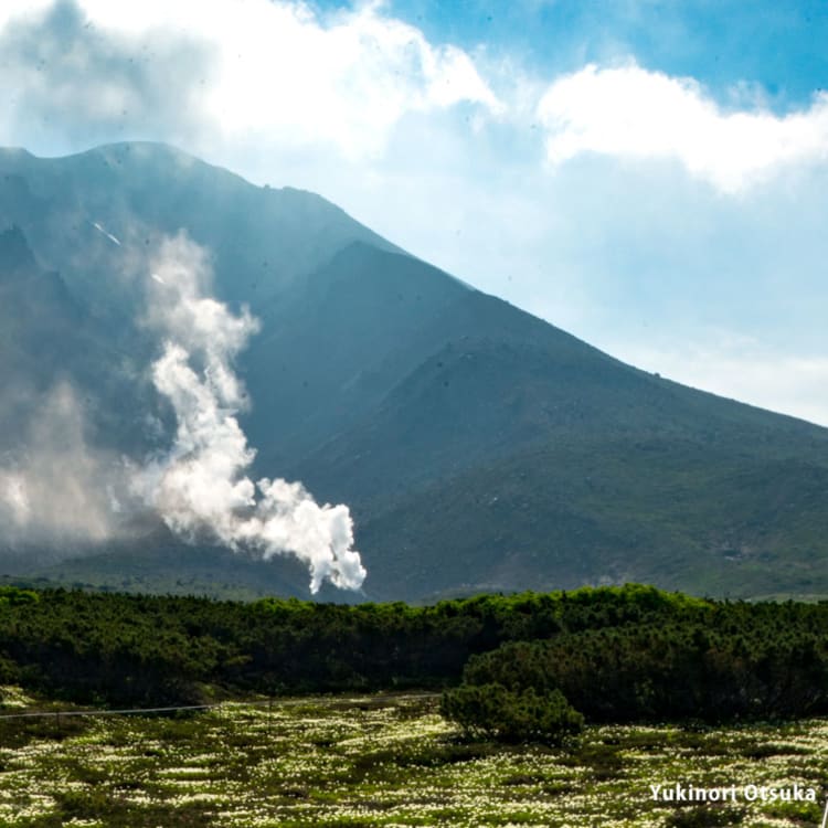
Continue on from here to reach the Sugatami Observation Point. This is the best spot to see Sugatami Pond with the towering Mt. Asahidake and volcanic smoke rising from vents in the ground as the backdrop. When the weather is good, Mt. Asahidake can be seen in the reflection of the water, making for a truly stunning view.

Right next to Sugatami Pond, you will find Asahidake Ishimuro, a cabin that can be used for emergency evacuation. Additionally, the location has a space with booths where you can use your portable toilet.

Make your way around from the Sugatami Observation Point with the pond on your left, to enjoy a close-up view of the fumarole of Jigokudani (hell's valley), from which impressive white smoke is emitted. This was formed around 1000 years ago by frequent eruptions of steam. This sight, representative of Sugatami Pond, is proof that Mt. Asahidake is still very much an active volcano.

As you continue ascending towards the summit, you will reach the eighth station which sits at around 2,080 meters above sea level. If you look up at the summit, there is a large section of the mountain where you can see the rough layers of rock laid bare before your eyes, the result of a collapse on the mountain around 600 years ago.

The number of rocky stretches and slippery areas increases the further up you go, so mind your footing and be careful not to trip and fall. Looking back down from here, you can enjoy a sweeping view of the spots you have passed along the way.

Shortly after passing the ninth station, the distinct shape of Kinko Rock will come into view. This is a sign you're not far from the summit. Although portable toilets are occasionally set up near Mount Asahidake's ninth station, they are often only available for limited periods of time, so it is best to check at the Asahidake Visitor Center in advance.

As you walk up the last of the meandering, steep hiking path, the view will suddenly open up, with an unobstructed 360-degree panoramic view spreading out before you. Take in the clean air and rest for a while as you take in your achievement of reaching the summit. When the weather is good, you can enjoy a view of famous Hokkaido peaks such as the Tokachidake Mountain Range and Mt. Tomuraushi, so don't forget to take a photo or two to remember this moment. Once you've enjoyed the summit, trace the path you hiked carefully back to Sugatami Station.
* Note: We will introduce other must-see areas on Mt. Asahidake, such as Susoaidaira Plateau and Nakadake Hot Springs. While there is another route going around the back of Mt. Asahidake to access these, it contains several areas with uneven footing and is difficult to hike. The less challenging walking course will be introduced below.
Hiking Course: Sugatami Station - Susoaidaira Plateau - Nakadake Hot Springs
Next, we will introduce the hiking course to Susoaidaira Plateau, a beautiful area home to alpine plants, from Asahidake Ropeway Sugatami Station. While there is little difference in elevation and a round trip can be made in 4-5 hours, the paths may have muddy leftover snow on them even during summer, so be sure to wear appropriate footwear.

As you follow the hiking path from Sugatami Station, two adjacent bowl-shaped ponds called Meoto Ponds will come into view. As is the case with Sugatami Pond, this pond was formed due to steam eruptions, and the stunning view of the blue sky reflected on the water's surface will have you gazing in admiration.

If you are lucky, you might come across the adorable Ezo chipmunk on Mt. Asahidake. If you find one, take care and observe quietly so as to not to startle them and scare them away.

On the route, you will find guideposts and signs in English and sections cordoned off with ropes. In the past, there have been cases of people wandering off the set path and getting stranded in the mountains; be sure to take a hiking map with you and follow the signs to enjoy a safe and pleasant hiking experience.

After continuing on the trail for a while, you will reach Susoaidaira Plateau, an area where alpine plants flourish. Between mid to late July, the plateau is covered in a wonderful sight of exquisite Aleutian avens, with the mountaintops in the background still covered in pristine white snow.

The Aleutian avens are at their most vibrant in mid-September, when they transform into a stunning crimson carpet.

From Susoaidaira Plateau, make your way down the wooden footpath to reach your next destination, Nakadake Hot Springs. Known as the "secret hot springs in the sky," Mt. Nakadake forms part of the Daisetsuzan Mountains and sits at an elevation of 1,800 meters. Dig into the river with a shovel to create your own natural foot bath filled with natural hot spring water. Give your feet a rest after all the walking while surrounded by beautiful nature.

After traversing the trail from Nakadake Onsen to return to Sugatami Station, your Asahidake hiking adventure comes to an end. The times for the Asahidake Ropeway vary depending on the season, so be sure to check the times for the last ride and plan your hike ahead of time.

Asahidake Hot Springs are located fairly close to Sanroku Station on the ropeway and are one of the leading historical hot springs in Hokkaido. They are known and loved by many hikers as a base for hiking Mt. Asahidake. Give yourself some much-needed rest with these relaxing natural hot springs and some delicious food.

Another nearby site to consider visiting is Hagoromo Falls in Tennin Gorge. Melted snow from Mt. Asahidake cascades down the edge of a cliff that was created by a volcanic explosion. The waterfall that falls into Tennin Gorge has a drop of 270 meters and is the second tallest in Japan.
What did you think of the Mt. Asahidake hiking article? The ropeway and hiking trails helps people of all fitness levels to experience the beauty and power of nature on Hokkaido's highest peak. In this article, we introduced a relatively safe route for beginners, but more seasoned hikers would no doubt enjoy the challenge of hiking from the base of the mountain without using the ropeway and may consider traversing the Daisetsuzan Mountains.
Please be aware that the environment of Mt. Asahidake, located at a high latitude, is said to rival that of mountains over 3000 meters tall on the island of Honshu. The area also sees sudden rain and wind, as well as low temperatures that cause snow and sleet to fall even in July, the middle of Japanese summer. Please ensure you are prepared for these conditions to make your hike a pleasurable and memorable one.
Links