


Travel Logs Mt. Kiso-Komagatake, Senjojiki Cirque

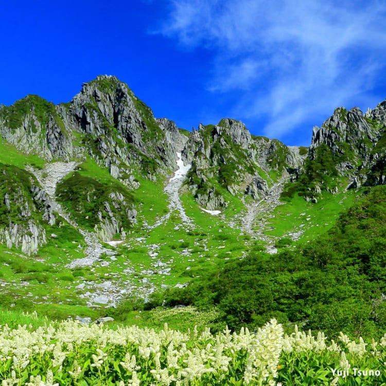
Mt. Kiso-Komagatake (2,956 m) is the tallest mountain in the Central Japanese Alps in Nagano Prefecture. The Central Japanese Alps are characterized by the unique shape of the mountain ranges, which is formed through repeated uplift force from the east and the west through crustal movements, producing beautiful scenery like a Japanese garden, with white granite and alpine plants.
The mountain is a popular hiking spot and boasts Japan’s largest group of granite massifs. The landscape also changes depending on the elevation and the climate, offering visitors opportunities to experience a variety of stunning scenes. Although the mountain is close to 3,000 meters tall, visitors can take the mountain bus and ropeway up to around the 2,600 meters point in around an hour. As a result, many mountain hikers love this mountain for its ease of access.
In this article, we will introduce the great features of Mt. Kiso-Komagatake through beautiful pictures taken by a mountain photographer who has been working for many years in the area. Follow the route from the trailhead in Senjojiki Cirque to Mt. Kiso-Komagatake to discover the incredible sights you will encounter on the mountain.

Yuji Tsuno
Yuji Tsuno is a mountain photographer and a guidebook writer based in Hase, Ina City, Nagano Prefecture. Since opening a photography office in 1992, he has continued to take photos of natural sceneries in Japan, focusing on mountainous terrain and has published his works in various print media. He often makes appearances as an instructor in photography sessions and seminars, as well as on TV. He has published more than 20 books, including photo collections, guidebooks, and photography manuals.

This hiking trip started from Shirabidaira Station, the first station of the Komagatake Ropeway. The station has a washroom and a shop where you can purchase goods and souvenirs. To get to Shirabidaira, people generally take a transit bus from Komagane Station on the JR Line or use the Komagane I.C. on the Chuo Expressway.

Once you go on the Komagatake Ropeway from Shirabidaira Station, you can enjoy a 7.5-minute ride up to the summit station, Senjojiki Station. With an altitude difference of 950 meters from the first and final station, you can enjoy a wide view of the glorious fresh greens in summer, and vivid leaves in autumn beneath you.

As you exit Senjojiki Station, Senjojiki Cirque spreads out before you. The station has two exits, one on the west and one on the east. Komagatake Shrine is located in an open space on the west side of the station, so visitors can visit here and pray for safe mountain hiking. This time, we took the east exit and headed towards the center of Senjojiki on the left. At the trailhead of Senjojiki, you will see a sign in English.

Start your hike and head towards Mt. Hokendake standing in front of you. The area around Kengaike Pond is a popular photography spot with a particularly beautiful view of the mountain. From here, you can admire the flower gardens in your surroundings before you continue to your next destination, the Haccho-zaka Road Fork.

When you arrive at the Haccho-zaka Road Fork, you can see a traversing path from Senjojiki Station and a walkway from Senjojiki Cirque merge. From here, Haccho-zaka’s path becomes narrow and steep. You can follow the signs written in English.

At the midpoint of Haccho-zaka, alpine plants such as shinanokinbai (Trollius shinanensis) and hakusan-ichige (Anemone narcissiflora) bloom with yellow and white flowers in summer, turning the whole area into a stunning alpine garden.

After you make it to the top of Haccho-zaka, you will reach Nokkoshijodo at an elevation of 2,853 meters. as the view opens up, you can marvel at all of Hoken-dake and the surrounding mountains. Take a moment to breathe in the fresh mountain air while admiring the beautiful scenery.

After reaching Nokkoshijodo, the path becomes relatively gentle for hikers. There is a sign at the fork indicating the path to the right leads to Mt. Inamae. Our next destination was Naka-dake, so we headed in the left direction towards Hoken Sanso, a mountain villa.

After walking for a while, you will see Hoken Sanso. It is fully equipped with accommodation, shops, and washrooms, and it is a convenient place to rest during bad weather (please note that a fee is required for resting and using the washroom). After our break, we headed to the back of the mountain villa towards Mt. Nakadake on the right side.

After passing Hoken Sanso, there is a fork with a large cairn. The left course travels on the left side of the Naka-dake summit. However, this course is rocky and windy, so this time, we went straight up and hiked up a wide path on a slope. You will then reach the Naka-dake summit after a brief walk.

When you reach the Naka-dake summit, you can see Komagatake in front of you. At the back, you can see Hoken-dake with its characteristic sharp peak shaped like a triangular pyramid. In the far-right direction, you can see Utsugi-dake and South Komagatake. You'll be able to take in the amazing views of the Southern Alps and Mt. Fuji on the east, and Mt. Ontake on the west.

From the summit of Komagatake, you hike down to the col before heading to the summit of Komagatake.

Chojo Sanso (mountain villa) stands on the col of Komagatake. You will find alpine plants growing in the area, such as dicentra and usuyukiso (Leontopodium japonicum). The area in front of the mountain villa is the only place where visitors can set up tents on the course. There is a restaurant, a shop and a washroom (for a fee), and accommodation is also available.

Koma-usuyukiso (Leontopodium shinanense) blooms in and around the summit area. This pure white, dainty flower is the world’s smallest type of edelweiss.

As you hike Komagatake, you might see a raicho (meaning thunder bird in English), a bird designated as a special natural treasure. It was said that raicho in the Central Alps had become extinct about half a century ago. However, Japan has been actively implementing measures to increase its population, so mountain hikers can now see these lovely birds.

This is finally the summit of Komagatake! To the east, you can see mountains toward Nogaike Pond and Shogishirayama. Here, you can enjoy the spectacular view of the Northern Alps, the Southern Alps, Mt. Fuji, Mt. Asama, Yatsugatake, and the main mountain ranges of Central Alps, and Mt. Ontake.

On the summit, there are two ancient shrines on the Kiso side and the Ina side. Both shrines enshrine a guardian of the mountain as the deity. Many hikers pray here to celebrate reaching the summit.

After fully enjoying the view at the summit, it’s time to hike down. Follow the exact same course you came from until you reach the Haccho-zaka Road Fork, then head to Senjojiki Station. If it’s a day trip, make sure to check the service hours of the ropeway and plan accordingly.

If you want to refresh your tired body after the hike, we recommend Hayataro Onsen-Kyo, a hot spring village at the foot of Komagatake. Relax in the natural hot springs while surrounded by mountains in the Southern Alps.

Kozenji Temple is close to Hayataro Onsen-Kyo, and is associated with the legendary dog Hayataro, which the hot spring village was named after. The temple is a popular stop for visitors and boasts three beautiful Japanese gardens. It is also famous for its luminous moss.

Komagane Plateau is a popular spot surrounded where you can enjoy outdoor sports and activities throughout the year. There are many resort hotels here, so you can relax here to enjoy the vast nature of Nagano Prefecture after mountain hiking.
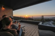
How was the hiking trip to Mt. Kiso-Komagatake? The chance to see a wide range of landscapes is one of the drawcards of the mountain. Visitors can learn about the natural world while immersing themselves in an extraordinary mountainous environment. The beautiful features of Komagatake can be enjoyed as a day trip of mountain hiking but if you have time, consider staying overnight at a mountain lodge on the ridge to enjoy the area during sunset and dawn. It will surely be a memorable experience.
Although the mountain is generally beginner-friendly, it can be dangerous depending on the season, climate, or the selected route. Be aware of your level of fitness research and prepare in advance to ensure a safe and enjoyable trip.
Links